SERVICES
SERVICES
Regulatory Compliance
- OSHA – Health and Safety Plans (29 CFR 1910.120)
- Hazardous Waste Management
- E-Waste Management
- Integrity Monitoring
- Environmental Permitting
- Resource Conservation and Recovery Act (RCRA) closures
- Spill Prevention Control & Counter Measures (SPCC)
- Stormwater Prevention & Control Plans (SPPP)
- Audit Record Management and Audit Report Preparation
- Environmental Impact Studies
- Environmental Site Assessments, Phase I and Phase II
- Water/Air Quality Testing
- Hazardous Waste Disposal, Small and Large Quantity Generators
REGULATORY COMPLIANCE
Brinkerhoff Environmental Services, Inc. provides Regulatory Compliance assistance for its Clients as their issues relate to local, state, and federal regulations. When conducting work, the firm follows all applicable regulations and makes remediation and permitting recommendations based on findings to avoid penalties and violations.
The firm regularly participates in Integrity Monitoring, overseeing the work of other firms to ensure results and regulatory compliance.
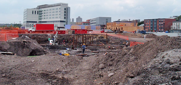
Activities associated with remediation projects often involve the demolition of buildings, removal of USTs, and excavation in contaminated areas. Because work in such areas often involves hazardous substances, activities are regulated under the Occupational Safety and Health Act (OSHA) laws, specifically 29 CFR 1910.120. The firm prepares plans that comply with all OSHA requirements.
Upon completion of an assessment to determine ISRA applicability, Brinkerhoff prepares recommendations on cost-effective options for bringing a property into viability for reuse or sale. If active remediation is necessary, Brinkerhoff directs labor and equipment to install various treatment systems. Examples include: multi-phase extraction systems for removal of gasoline, diesel and fuel oil products; air stripping units for removal of volatile organic substances, including petroleum-based solvents; and, air sparge and vacuum extraction systems for volatilizing and venting chemical substances.
Brinkerhoff assists property owners and responsible parties with evaluating the environmental impact of contamination and NRD. Such resources include groundwater, wetlands, and habitats of endangered species.
Brinkerhoff directs waste management, disposal of regulated substances, waste manifestation and selection of disposal facilities to minimize costs and avoid future litigation and regulatory fines. Our services include state and local agency coordination, preparation of reports as required for regulatory compliance, waste management (hazardous and non-hazardous), and project closeout-cost accounting.
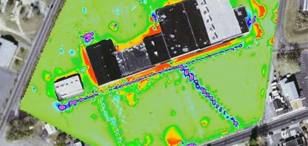
Brinkerhoff provides geophysical scanning services to locate drums, underground storage tanks, foundations, septic systems, abandoned mine shafts, utilities and other buried objects to depths of 25 feet and greater. Our innovative technologies are state-of-the art and provide clear data with consistent results.
The Magnetic and Ground-Penetrating Radar (GPR) systems we use deliver instantaneous, real time data, displayed on a computer in the field. Scanned data can be checked from a variety of approach directions to verify the type of subsurface anomalies encountered. When necessary, suspect areas can be rescanned in the field with higher accuracy.
Field data are tied to satellite global positioning systems (GPS) for location accuracy. This information may easily be used to relocate anomalies at a later date when construction, demolition or drilling activities are underway. Data can be electronically transmitted from the field to the office for further evaluation. Data printouts and displays provide graphic results in 2-D & 3-D that can be easily interpreted and reviewed. The data can also be inverted and rotated for various views of subsurface conditions.
Brinkerhoff Environmental Services, Inc. performs Due Diligence inspections and investigations of real property for Clients entering into to real estate acquisition, mergers and loan transactions. Brinkerhoff provides our Clients with information, recommendations, and options to meet their objectives, and is dedicated to providing technical excellence at competitive rates.
Brinkerhoff prepares Phase I Environmental Site Assessments (ESAs), which exceed recognized ASTM standards (E1527-13). Our approach includes the following:
INDUSTRIAL SITE RECOVERY ACT (ISRA) COMPLIANCE
NATURAL RESOURCE DAMAGE (NRD) ASSESSMENTS
HAZARDOUS WASTE MANAGEMENT
HI-RESOLUTION GEOPHYSICS
Brinkerhoff provides geophysical scanning services to locate drums, underground storage tanks, foundations, septic systems, abandoned mine shafts, utilities and other buried objects to depths of 25 feet and greater. Our innovative technologies are state-of-the art and provide clear data with consistent results.
The Magnetic and Ground-Penetrating Radar (GPR) systems we use deliver instantaneous, real time data, displayed on a computer in the field. Scanned data can be checked from a variety of approach directions to verify the type of subsurface anomalies encountered. When necessary, suspect areas can be rescanned in the field with higher accuracy.
Field data are tied to satellite global positioning systems (GPS) for location accuracy. This information may easily be used to relocate anomalies at a later date when construction, demolition or drilling activities are underway. Data can be electronically transmitted from the field to the office for further evaluation. Data printouts and displays provide graphic results in 2-D & 3-D that can be easily interpreted and reviewed. The data can also be inverted and rotated for various views of subsurface conditions.